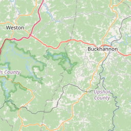
USGS NWIS Stream/River/Lake Site 03051500: MIDDLE FORK RIVER AT MIDVALE, WV
Map


Leaflet | <a href="https://www.openstreetmap.org/copyright">© OpenStreetMap contributors</a>
Item
| Property | Value |
|---|---|
| id | 1017776 |
| cluster | None |
| dasqkm_diff | 0.899999999999977 |
| description | USGS NWIS Stream/River/Lake Site 03051500: MIDDLE FORK RIVER AT MIDVALE, WV |
| fid | 16167 |
| gage_totdasqkm | 318.6 |
| mainstem_uri | https://geoconnex.us/ref/mainstems/397500 |
| name | MIDDLE FORK RIVER AT MIDVALE, WV |
| nhdpv2_comid | 4353332.0 |
| nhdpv2_link_source | https://doi.org/10.5066/P9J5CK2Y |
| nhdpv2_offset_m | 0.836125955337291 |
| nhdpv2_reach_measure | 5.554 |
| nhdpv2_reachcode | 05020001000146 |
| nhdpv2_totdasqkm | 319.5 |
| nws_url | None |
| provider | https://waterdata.usgs.gov |
| provider_id | 03051500 |
| subjectof | https://waterdata.usgs.gov/monitoring-location/03051500 |
| uri | https://geoconnex.us/ref/gages/1017776 |