USGS NWIS Stream/River/Lake Site 01168230: PELHAM BROOK AT ZOAR, MA
Map
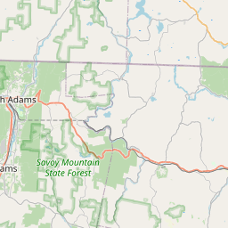


Leaflet | <a href="https://www.openstreetmap.org/copyright">© OpenStreetMap contributors</a>
Item
| Property | Value |
|---|---|
| id | 1019119 |
| cluster | None |
| dasqkm_diff | 0.600000000000001 |
| description | USGS NWIS Stream/River/Lake Site 01168230: PELHAM BROOK AT ZOAR, MA |
| fid | 17296 |
| gage_totdasqkm | 35.0 |
| mainstem_uri | None |
| name | PELHAM BROOK AT ZOAR, MA |
| nhdpv2_comid | 10294750.0 |
| nhdpv2_link_source | https://github.com/internetofwater/ref_gages |
| nhdpv2_offset_m | 14.4997573753525 |
| nhdpv2_reach_measure | 24.0665 |
| nhdpv2_reachcode | 01080203000066 |
| nhdpv2_totdasqkm | 35.6 |
| nws_url | None |
| provider | https://waterdata.usgs.gov |
| provider_id | 01168230 |
| subjectof | https://waterdata.usgs.gov/monitoring-location/01168230 |
| uri | https://geoconnex.us/ref/gages/1019119 |