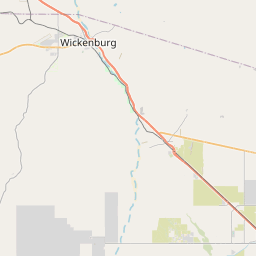
USGS NWIS Stream/River/Lake Site 09512860: HUMBUG CREEK, NEAR CASTLE HOT SPRINGS, AZ
Map


Leaflet | <a href="https://www.openstreetmap.org/copyright">© OpenStreetMap contributors</a>
Item
| Property | Value |
|---|---|
| id | 1063188 |
| cluster | None |
| dasqkm_diff | 0.800000000000011 |
| description | USGS NWIS Stream/River/Lake Site 09512860: HUMBUG CREEK, NEAR CASTLE HOT SPRINGS, AZ |
| fid | 190274 |
| gage_totdasqkm | 155.1 |
| mainstem_uri | https://geoconnex.us/ref/mainstems/49004 |
| name | HUMBUG CREEK, NEAR CASTLE HOT SPRINGS, AZ |
| nhdpv2_comid | 20415700.0 |
| nhdpv2_link_source | https://www.epa.gov/waterdata/nhdplus-national-hydrography-dataset-plus |
| nhdpv2_offset_m | 41.7533961118771 |
| nhdpv2_reach_measure | 38.9905 |
| nhdpv2_reachcode | 15070102000247 |
| nhdpv2_totdasqkm | 155.9 |
| nws_url | None |
| provider | https://waterdata.usgs.gov |
| provider_id | 09512860 |
| subjectof | https://waterdata.usgs.gov/monitoring-location/09512860 |
| uri | https://geoconnex.us/ref/gages/1063188 |