USGS NWIS Stream/River/Lake Site 05472500: North Skunk River near Sigourney, IA
Map
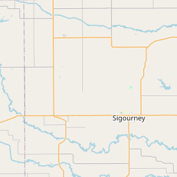

Leaflet | <a href="https://www.openstreetmap.org/copyright">© OpenStreetMap contributors</a>
Item
| Property | Value |
|---|---|
| id | 1070689 |
| cluster | None |
| dasqkm_diff | 8.39999999999986 |
| description | USGS NWIS Stream/River/Lake Site 05472500: North Skunk River near Sigourney, IA |
| fid | 61544 |
| gage_totdasqkm | 1890.7 |
| mainstem_uri | https://geoconnex.us/ref/mainstems/345036 |
| name | North Skunk River near Sigourney, IA |
| nhdpv2_comid | 6996297.0 |
| nhdpv2_link_source | https://doi.org/10.5066/P9J5CK2Y |
| nhdpv2_offset_m | 2.23370189791797 |
| nhdpv2_reach_measure | 11.63 |
| nhdpv2_reachcode | 07080106000047 |
| nhdpv2_totdasqkm | 1899.1 |
| nws_url | https://water.noaa.gov/gauges/SIGI4 |
| provider | https://waterdata.usgs.gov |
| provider_id | 05472500 |
| subjectof | https://waterdata.usgs.gov/monitoring-location/05472500 |
| uri | https://geoconnex.us/ref/gages/1070689 |