USGS NWIS Stream/River/Lake Site 01374496: EAST BRANCH CROTON RIVER NEAR BREWSTER NY
Map
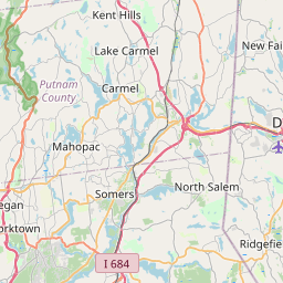

Leaflet | <a href="https://www.openstreetmap.org/copyright">© OpenStreetMap contributors</a>
Item
| Property | Value |
|---|---|
| id | 1071898 |
| cluster | None |
| dasqkm_diff | -11.3 |
| description | USGS NWIS Stream/River/Lake Site 01374496: EAST BRANCH CROTON RIVER NEAR BREWSTER NY |
| fid | 62531 |
| gage_totdasqkm | 205.9 |
| mainstem_uri | https://geoconnex.us/ref/mainstems/2105248 |
| name | EAST BRANCH CROTON RIVER NEAR BREWSTER NY |
| nhdpv2_comid | 6227126.0 |
| nhdpv2_link_source | https://github.com/internetofwater/ref_gages |
| nhdpv2_offset_m | 30.1797823109444 |
| nhdpv2_reach_measure | 39.7704 |
| nhdpv2_reachcode | 02030101000027 |
| nhdpv2_totdasqkm | 194.6 |
| nws_url | None |
| provider | https://waterdata.usgs.gov |
| provider_id | 01374496 |
| subjectof | https://waterdata.usgs.gov/monitoring-location/01374496 |
| uri | https://geoconnex.us/ref/gages/1071898 |