USGS NWIS Stream/River/Lake Site 00004265: E-03 Charenton (Atchafalaya side)
Map
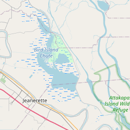


Leaflet | <a href="https://www.openstreetmap.org/copyright">© OpenStreetMap contributors</a>
Item
| Property | Value |
|---|---|
| id | 1121068 |
| cluster | https://geoconnex.us/ref/gages/1121069,https://geoconnex.us/ref/gages/1121775 |
| dasqkm_diff | None |
| description | USGS NWIS Stream/River/Lake Site 00004265: E-03 Charenton (Atchafalaya side) |
| fid | 99107 |
| gage_totdasqkm | None |
| mainstem_uri | None |
| name | E-03 Charenton (Atchafalaya side) |
| nhdpv2_comid | 15181955.0 |
| nhdpv2_link_source | https://github.com/internetofwater/ref_gages |
| nhdpv2_offset_m | 46.9698780962328 |
| nhdpv2_reach_measure | 100.0 |
| nhdpv2_reachcode | 08080101006772 |
| nhdpv2_totdasqkm | 0.2 |
| nws_url | None |
| provider | https://waterdata.usgs.gov |
| provider_id | 00004265 |
| subjectof | https://waterdata.usgs.gov/monitoring-location/00004265 |
| uri | https://geoconnex.us/ref/gages/1121068 |