North Fork Middle Fork Willamette River
Map
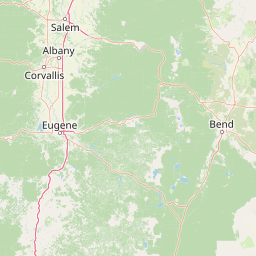


Leaflet | <a href="https://www.openstreetmap.org/copyright">© OpenStreetMap contributors</a>
Item
| Property | Value |
|---|---|
| id | 1435560 |
| downstream_mainstem_id | https://geoconnex.us/ref/mainstems/1426120 |
| encompassing_mainstem_basins | ['https://geoconnex.us/ref/mainstems/1426120', 'https://geoconnex.us/ref/mainstems/1423587'] |
| featuretype | ['https://www.opengis.net/def/schema/hy_features/hyf/HY_FlowPath', 'https://www.opengis.net/def/schema/hy_features/hyf/HY_WaterBody'] |
| fid | 31149 |
| head_2020huc12 | 170900010601 |
| head_nhdpv1_comid | 23752414 |
| head_nhdpv2_comid | https://geoconnex.us/nhdplusv2/comid/23752414 |
| head_nhdpv2huc12 | https://geoconnex.us/nhdplusv2/huc12/170900010601 |
| head_rf1id | 52548 |
| lengthkm | 79.7 |
| name_at_outlet | North Fork Middle Fork Willamette River |
| name_at_outlet_gnis_id | 1146981 |
| new_mainstemid | |
| outlet_2020huc12 | 170900010608 |
| outlet_drainagearea_sqkm | 645.8 |
| outlet_nhdpv1_comid | 23752446 |
| outlet_nhdpv2_comid | https://geoconnex.us/nhdplusv2/comid/23752446 |
| outlet_nhdpv2huc12 | https://geoconnex.us/nhdplusv2/huc12/170900010608 |
| outlet_rf1id | 52542 |
| superseded | False |
| uri | https://geoconnex.us/ref/mainstems/1435560 |
Graph Results
| monitoringLocation | https://sta.geoconnex.dev/collections/USGS/Things/items/'USGS-14147500' |
|---|---|
| siteName | USGS-14147500 |
| datasetDescription | DCP battery voltage / USGS-14147500-b408ee89d78c4d41bb4ccff64f54a398 |
| type | Stream |
| url | https://waterdata.usgs.gov/monitoring-location/14147500/#parameterCode=70969 |
| variableMeasured | DCP battery voltage / USGS-14147500-b408ee89d78c4d41bb4ccff64f54a398 |
| variableUnit | V |
| measurementTechnique | observation |
| temporalCoverage | 2024-08-30T10:00:00Z/2024-09-09T18:00:00Z |
| distributionName | USGS Instantaneous Values Service |
| distributionURL | https://waterservices.usgs.gov/nwis/iv/?sites=USGS:14147500¶meterCd=70969&format=rdb |
| distributionFormat | text/tab-separated-values |
| wkt | POINT (-122.505329201326 43.7567902423058) |
| monitoringLocation | https://sta.geoconnex.dev/collections/USGS/Things/items/'USGS-14147500' |
|---|---|
| siteName | USGS-14147500 |
| datasetDescription | DCP battery voltage / USGS-14147500-b408ee89d78c4d41bb4ccff64f54a398 |
| type | Stream |
| url | https://waterdata.usgs.gov/monitoring-location/14147500/#parameterCode=70969 |
| variableMeasured | DCP battery voltage / USGS-14147500-b408ee89d78c4d41bb4ccff64f54a398 |
| variableUnit | V |
| measurementTechnique | observation |
| temporalCoverage | 2024-08-30T10:00:00Z/2024-09-09T18:00:00Z |
| distributionName | USGS SensorThings API |
| distributionURL | https://labs.waterdata.usgs.gov/sta/v1.1/Datastreams('b408ee89d78c4d41bb4ccff64f54a398')?$expand=Thing,Observations |
| distributionFormat | application/json |
| wkt | POINT (-122.505329201326 43.7567902423058) |
| monitoringLocation | https://sta.geoconnex.dev/collections/USGS/Things/items/'USGS-14147500' |
|---|---|
| siteName | USGS-14147500 |
| datasetDescription | Temperature, water / USGS-14147500-465a8ec3dab44aec9405de200e404a29 |
| type | Stream |
| url | https://waterdata.usgs.gov/monitoring-location/14147500/#parameterCode=00010 |
| variableMeasured | Temperature |
| variableUnit | degC |
| measurementTechnique | observation |
| temporalCoverage | 2024-08-30T09:10:00Z/2024-09-09T19:00:00Z |
| distributionName | USGS Instantaneous Values Service |
| distributionURL | https://waterservices.usgs.gov/nwis/iv/?sites=USGS:14147500¶meterCd=00010&format=rdb |
| distributionFormat | text/tab-separated-values |
| wkt | POINT (-122.505329201326 43.7567902423058) |
| monitoringLocation | https://sta.geoconnex.dev/collections/USGS/Things/items/'USGS-14147500' |
|---|---|
| siteName | USGS-14147500 |
| datasetDescription | Temperature, water / USGS-14147500-465a8ec3dab44aec9405de200e404a29 |
| type | Stream |
| url | https://waterdata.usgs.gov/monitoring-location/14147500/#parameterCode=00010 |
| variableMeasured | Temperature |
| variableUnit | degC |
| measurementTechnique | observation |
| temporalCoverage | 2024-08-30T09:10:00Z/2024-09-09T19:00:00Z |
| distributionName | USGS SensorThings API |
| distributionURL | https://labs.waterdata.usgs.gov/sta/v1.1/Datastreams('465a8ec3dab44aec9405de200e404a29')?$expand=Thing,Observations |
| distributionFormat | application/json |
| wkt | POINT (-122.505329201326 43.7567902423058) |
| monitoringLocation | https://sta.geoconnex.dev/collections/USGS/Things/items/'USGS-14147500' |
|---|---|
| siteName | USGS-14147500 |
| datasetDescription | Gage height / USGS-14147500-7f896af4d1a4492b81ac1d4d29efc84f |
| type | Stream |
| url | https://waterdata.usgs.gov/monitoring-location/14147500/#parameterCode=00065 |
| variableMeasured | Gage height / USGS-14147500-7f896af4d1a4492b81ac1d4d29efc84f |
| variableUnit | ft |
| measurementTechnique | observation |
| temporalCoverage | 2024-08-30T09:10:00Z/2024-09-09T19:00:00Z |
| distributionName | USGS Instantaneous Values Service |
| distributionURL | https://waterservices.usgs.gov/nwis/iv/?sites=USGS:14147500¶meterCd=00065&format=rdb |
| distributionFormat | text/tab-separated-values |
| wkt | POINT (-122.505329201326 43.7567902423058) |
| monitoringLocation | https://sta.geoconnex.dev/collections/USGS/Things/items/'USGS-14147500' |
|---|---|
| siteName | USGS-14147500 |
| datasetDescription | Gage height / USGS-14147500-7f896af4d1a4492b81ac1d4d29efc84f |
| type | Stream |
| url | https://waterdata.usgs.gov/monitoring-location/14147500/#parameterCode=00065 |
| variableMeasured | Gage height / USGS-14147500-7f896af4d1a4492b81ac1d4d29efc84f |
| variableUnit | ft |
| measurementTechnique | observation |
| temporalCoverage | 2024-08-30T09:10:00Z/2024-09-09T19:00:00Z |
| distributionName | USGS SensorThings API |
| distributionURL | https://labs.waterdata.usgs.gov/sta/v1.1/Datastreams('7f896af4d1a4492b81ac1d4d29efc84f')?$expand=Thing,Observations |
| distributionFormat | application/json |
| wkt | POINT (-122.505329201326 43.7567902423058) |