Winchester Wasteway
Map


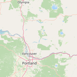


Leaflet | <a href="https://www.openstreetmap.org/copyright">© OpenStreetMap contributors</a>
Item
| Property | Value |
|---|---|
| id | 1435920 |
| downstream_mainstem_id | https://geoconnex.us/ref/mainstems/1429069 |
| encompassing_mainstem_basins | ['https://geoconnex.us/ref/mainstems/1429069', 'https://geoconnex.us/ref/mainstems/1423587'] |
| featuretype | ['https://www.opengis.net/def/schema/hy_features/hyf/HY_FlowPath', 'https://www.opengis.net/def/schema/hy_features/hyf/HY_WaterBody'] |
| fid | 29297 |
| head_2020huc12 | 170200150503 |
| head_nhdpv1_comid | None |
| head_nhdpv2_comid | https://geoconnex.us/nhdplusv2/comid/947020547 |
| head_nhdpv2huc12 | https://geoconnex.us/nhdplusv2/huc12/170200150503 |
| head_rf1id | None |
| lengthkm | 58.7 |
| name_at_outlet | Winchester Wasteway |
| name_at_outlet_gnis_id | 1509586 |
| new_mainstemid | |
| outlet_2020huc12 | 170200150507 |
| outlet_drainagearea_sqkm | 704.2 |
| outlet_nhdpv1_comid | None |
| outlet_nhdpv2_comid | https://geoconnex.us/nhdplusv2/comid/947020401 |
| outlet_nhdpv2huc12 | https://geoconnex.us/nhdplusv2/huc12/170200150507 |
| outlet_rf1id | None |
| superseded | False |
| uri | https://geoconnex.us/ref/mainstems/1435920 |