Trout Lake Creek
Map
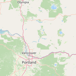


Leaflet | <a href="https://www.openstreetmap.org/copyright">© OpenStreetMap contributors</a>
Item
| Property | Value |
|---|---|
| id | 1460448 |
| downstream_mainstem_id | https://geoconnex.us/ref/mainstems/1440592 |
| encompassing_mainstem_basins | ['https://geoconnex.us/ref/mainstems/1440592', 'https://geoconnex.us/ref/mainstems/1423587'] |
| featuretype | ['https://www.opengis.net/def/schema/hy_features/hyf/HY_FlowPath', 'https://www.opengis.net/def/schema/hy_features/hyf/HY_WaterBody'] |
| fid | 30780 |
| head_2020huc12 | 170701050804 |
| head_nhdpv1_comid | 24505398 |
| head_nhdpv2_comid | https://geoconnex.us/nhdplusv2/comid/24505398 |
| head_nhdpv2huc12 | https://geoconnex.us/nhdplusv2/huc12/170701050804 |
| head_rf1id | 51581 |
| lengthkm | 32.9 |
| name_at_outlet | Trout Lake Creek |
| name_at_outlet_gnis_id | 1527418 |
| new_mainstemid | |
| outlet_2020huc12 | 170701050805 |
| outlet_drainagearea_sqkm | 233.2 |
| outlet_nhdpv1_comid | 24504880 |
| outlet_nhdpv2_comid | https://geoconnex.us/nhdplusv2/comid/24504880 |
| outlet_nhdpv2huc12 | https://geoconnex.us/nhdplusv2/huc12/170701050805 |
| outlet_rf1id | 51581 |
| superseded | False |
| uri | https://geoconnex.us/ref/mainstems/1460448 |