Coal Mine Creek
Map
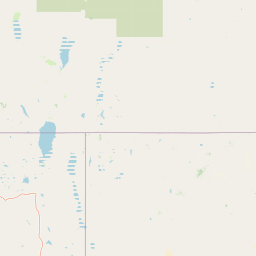


Leaflet | <a href="https://www.openstreetmap.org/copyright">© OpenStreetMap contributors</a>
Item
| Property | Value |
|---|---|
| id | 1936274 |
| downstream_mainstem_id | https://geoconnex.us/ref/mainstems/1934828 |
| encompassing_mainstem_basins | ['https://geoconnex.us/ref/mainstems/1934828'] |
| featuretype | ['https://www.opengis.net/def/schema/hy_features/hyf/HY_FlowPath', 'https://www.opengis.net/def/schema/hy_features/hyf/HY_WaterBody'] |
| fid | 27963 |
| head_2020huc12 | 160401010801 |
| head_nhdpv1_comid | 10777352 |
| head_nhdpv2_comid | https://geoconnex.us/nhdplusv2/comid/10777352 |
| head_nhdpv2huc12 | https://geoconnex.us/nhdplusv2/huc12/160401010801 |
| head_rf1id | 44911 |
| lengthkm | 33.2 |
| name_at_outlet | Coal Mine Creek |
| name_at_outlet_gnis_id | 856214 |
| new_mainstemid | |
| outlet_2020huc12 | 160401010802 |
| outlet_drainagearea_sqkm | 202.7 |
| outlet_nhdpv1_comid | 10784406 |
| outlet_nhdpv2_comid | https://geoconnex.us/nhdplusv2/comid/10784406 |
| outlet_nhdpv2huc12 | https://geoconnex.us/nhdplusv2/huc12/160401010802 |
| outlet_rf1id | 44911 |
| superseded | False |
| uri | https://geoconnex.us/ref/mainstems/1936274 |