Castle Creek
Map
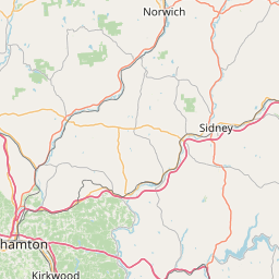
Leaflet | <a href="https://www.openstreetmap.org/copyright">© OpenStreetMap contributors</a>
Item
| Property | Value |
|---|---|
| id | 207777 |
| downstream_mainstem_id | https://geoconnex.us/ref/mainstems/197029 |
| encompassing_mainstem_basins | ['https://geoconnex.us/ref/mainstems/197029', 'https://geoconnex.us/ref/mainstems/195069', 'https://geoconnex.us/ref/mainstems/194408'] |
| featuretype | ['https://www.opengis.net/def/schema/hy_features/hyf/HY_FlowPath', 'https://www.opengis.net/def/schema/hy_features/hyf/HY_WaterBody'] |
| fid | 1491 |
| head_2020huc12 | 020501050103 |
| head_nhdpv1_comid | 8119151 |
| head_nhdpv2_comid | https://geoconnex.us/nhdplusv2/comid/8119151 |
| head_nhdpv2huc12 | https://geoconnex.us/nhdplusv2/huc12/020501050103 |
| head_rf1id | 3194 |
| lengthkm | 10.0 |
| name_at_outlet | Castle Creek |
| name_at_outlet_gnis_id | 945987 |
| new_mainstemid | |
| outlet_2020huc12 | 020501050103 |
| outlet_drainagearea_sqkm | 78.7 |
| outlet_nhdpv1_comid | 8118829 |
| outlet_nhdpv2_comid | https://geoconnex.us/nhdplusv2/comid/8118829 |
| outlet_nhdpv2huc12 | https://geoconnex.us/nhdplusv2/huc12/020501050103 |
| outlet_rf1id | 3194 |
| superseded | False |
| uri | https://geoconnex.us/ref/mainstems/207777 |