Slocums River
Map
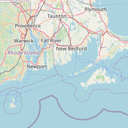

Leaflet | <a href="https://www.openstreetmap.org/copyright">© OpenStreetMap contributors</a>
Item
| Property | Value |
|---|---|
| id | 2292438 |
| downstream_mainstem_id | |
| encompassing_mainstem_basins | |
| featuretype | ['https://www.opengis.net/def/schema/hy_features/hyf/HY_FlowPath', 'https://www.opengis.net/def/schema/hy_features/hyf/HY_WaterBody'] |
| fid | 797 |
| head_2020huc12 | 010900020402 |
| head_nhdpv1_comid | 5879125 |
| head_nhdpv2_comid | https://geoconnex.us/nhdplusv2/comid/5879125 |
| head_nhdpv2huc12 | https://geoconnex.us/nhdplusv2/huc12/010900020402 |
| head_rf1id | 1416 |
| lengthkm | 19.8 |
| name_at_outlet | Slocums River |
| name_at_outlet_gnis_id | 618723 |
| new_mainstemid | |
| outlet_2020huc12 | 010900020402 |
| outlet_drainagearea_sqkm | 88.8 |
| outlet_nhdpv1_comid | 5881821 |
| outlet_nhdpv2_comid | https://geoconnex.us/nhdplusv2/comid/5881821 |
| outlet_nhdpv2huc12 | https://geoconnex.us/nhdplusv2/huc12/010900020402 |
| outlet_rf1id | 1415 |
| superseded | False |
| uri | https://geoconnex.us/ref/mainstems/2292438 |
Graph Results
| monitoringLocation | https://sta.geoconnex.dev/collections/USGS/Things/items/'USGS-01105933' |
|---|---|
| siteName | USGS-01105933 |
| datasetDescription | Gage height, feet / USGS-01105933-661dcd9c88f14527accdc06009bcfd36 |
| type | Stream |
| url | https://waterdata.usgs.gov/monitoring-location/01105933/#parameterCode=00065 |
| variableMeasured | Gage height |
| variableUnit | ft |
| measurementTechnique | observation |
| temporalCoverage | 2024-08-30T09:15:00Z/2024-09-09T18:15:00Z |
| distributionName | USGS Instantaneous Values Service |
| distributionURL | https://waterservices.usgs.gov/nwis/iv/?sites=USGS:01105933¶meterCd=00065&format=rdb |
| distributionFormat | text/tab-separated-values |
| wkt | POINT (-70.9903171021358 41.5853818540787) |
| monitoringLocation | https://sta.geoconnex.dev/collections/USGS/Things/items/'USGS-01105933' |
|---|---|
| siteName | USGS-01105933 |
| datasetDescription | Gage height, feet / USGS-01105933-661dcd9c88f14527accdc06009bcfd36 |
| type | Stream |
| url | https://waterdata.usgs.gov/monitoring-location/01105933/#parameterCode=00065 |
| variableMeasured | Gage height |
| variableUnit | ft |
| measurementTechnique | observation |
| temporalCoverage | 2024-08-30T09:15:00Z/2024-09-09T18:15:00Z |
| distributionName | USGS SensorThings API |
| distributionURL | https://labs.waterdata.usgs.gov/sta/v1.1/Datastreams('661dcd9c88f14527accdc06009bcfd36')?$expand=Thing,Observations |
| distributionFormat | application/json |
| wkt | POINT (-70.9903171021358 41.5853818540787) |
| monitoringLocation | https://sta.geoconnex.dev/collections/USGS/Things/items/'USGS-01105933' |
|---|---|
| siteName | USGS-01105933 |
| datasetDescription | Discharge, cubic feet per second / USGS-01105933-ac1817b68c814e12a8f8ff4bf6c8c3f0 |
| type | Stream |
| url | https://waterdata.usgs.gov/monitoring-location/01105933/#parameterCode=00060 |
| variableMeasured | Discharge |
| variableUnit | ft^3/s |
| measurementTechnique | observation |
| temporalCoverage | 2024-08-30T09:15:00Z/2024-09-09T18:15:00Z |
| distributionName | USGS Instantaneous Values Service |
| distributionURL | https://waterservices.usgs.gov/nwis/iv/?sites=USGS:01105933¶meterCd=00060&format=rdb |
| distributionFormat | text/tab-separated-values |
| wkt | POINT (-70.9903171021358 41.5853818540787) |
| monitoringLocation | https://sta.geoconnex.dev/collections/USGS/Things/items/'USGS-01105933' |
|---|---|
| siteName | USGS-01105933 |
| datasetDescription | Discharge, cubic feet per second / USGS-01105933-ac1817b68c814e12a8f8ff4bf6c8c3f0 |
| type | Stream |
| url | https://waterdata.usgs.gov/monitoring-location/01105933/#parameterCode=00060 |
| variableMeasured | Discharge |
| variableUnit | ft^3/s |
| measurementTechnique | observation |
| temporalCoverage | 2024-08-30T09:15:00Z/2024-09-09T18:15:00Z |
| distributionName | USGS SensorThings API |
| distributionURL | https://labs.waterdata.usgs.gov/sta/v1.1/Datastreams('ac1817b68c814e12a8f8ff4bf6c8c3f0')?$expand=Thing,Observations |
| distributionFormat | application/json |
| wkt | POINT (-70.9903171021358 41.5853818540787) |