Clarks Creek
Map
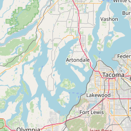
Leaflet | <a href="https://www.openstreetmap.org/copyright">© OpenStreetMap contributors</a>
Item
| Property | Value |
|---|---|
| id | 2341329 |
| downstream_mainstem_id | https://geoconnex.us/ref/mainstems/2340797 |
| encompassing_mainstem_basins | ['https://geoconnex.us/ref/mainstems/2340797'] |
| featuretype | ['https://www.opengis.net/def/schema/hy_features/hyf/HY_FlowPath', 'https://www.opengis.net/def/schema/hy_features/hyf/HY_WaterBody'] |
| fid | 31782 |
| head_2020huc12 | |
| head_nhdpv1_comid | 23981667 |
| head_nhdpv2_comid | https://geoconnex.us/nhdplusv2/comid/23981667 |
| head_nhdpv2huc12 | |
| head_rf1id | None |
| lengthkm | 6.1 |
| name_at_outlet | Clarks Creek |
| name_at_outlet_gnis_id | 1503998 |
| new_mainstemid | |
| outlet_2020huc12 | |
| outlet_drainagearea_sqkm | 69.8 |
| outlet_nhdpv1_comid | 23982323 |
| outlet_nhdpv2_comid | https://geoconnex.us/nhdplusv2/comid/23982323 |
| outlet_nhdpv2huc12 | |
| outlet_rf1id | None |
| superseded | False |
| uri | https://geoconnex.us/ref/mainstems/2341329 |
Graph Results
| monitoringLocation | https://sta.geoconnex.dev/collections/USGS/Things/items/'USGS-12102060' |
|---|---|
| siteName | USGS-12102060 |
| datasetDescription | Gage height feet / USGS-12102060-917c4c8a0fb84b258d37b06f2895a4d0 |
| type | Stream |
| url | https://waterdata.usgs.gov/monitoring-location/12102060/#parameterCode=00065 |
| variableMeasured | Gage height |
| variableUnit | ft |
| measurementTechnique | observation |
| temporalCoverage | 2024-08-30T09:15:00Z/2024-09-09T18:30:00Z |
| distributionName | USGS Instantaneous Values Service |
| distributionURL | https://waterservices.usgs.gov/nwis/iv/?sites=USGS:12102060¶meterCd=00065&format=rdb |
| distributionFormat | text/tab-separated-values |
| wkt | POINT (-122.3417876 47.2009334) |
| monitoringLocation | https://sta.geoconnex.dev/collections/USGS/Things/items/'USGS-12102060' |
|---|---|
| siteName | USGS-12102060 |
| datasetDescription | Gage height feet / USGS-12102060-917c4c8a0fb84b258d37b06f2895a4d0 |
| type | Stream |
| url | https://waterdata.usgs.gov/monitoring-location/12102060/#parameterCode=00065 |
| variableMeasured | Gage height |
| variableUnit | ft |
| measurementTechnique | observation |
| temporalCoverage | 2024-08-30T09:15:00Z/2024-09-09T18:30:00Z |
| distributionName | USGS SensorThings API |
| distributionURL | https://labs.waterdata.usgs.gov/sta/v1.1/Datastreams('917c4c8a0fb84b258d37b06f2895a4d0')?$expand=Thing,Observations |
| distributionFormat | application/json |
| wkt | POINT (-122.3417876 47.2009334) |
| monitoringLocation | https://sta.geoconnex.dev/collections/USGS/Things/items/'USGS-12102060' |
|---|---|
| siteName | USGS-12102060 |
| datasetDescription | Dissolved oxygen water unfiltered milligrams per liter / USGS-12102060-cf62e4e6ebfd483cbcaed1f76ebc8aa8 |
| type | Stream |
| url | https://waterdata.usgs.gov/monitoring-location/12102060/#parameterCode=00300 |
| variableMeasured | Dissolved oxygen |
| variableUnit | mg/l |
| measurementTechnique | observation |
| temporalCoverage | 2024-08-30T09:15:00Z/2024-09-09T18:30:00Z |
| distributionName | USGS SensorThings API |
| distributionURL | https://labs.waterdata.usgs.gov/sta/v1.1/Datastreams('cf62e4e6ebfd483cbcaed1f76ebc8aa8')?$expand=Thing,Observations |
| distributionFormat | application/json |
| wkt | POINT (-122.3417876 47.2009334) |
| monitoringLocation | https://sta.geoconnex.dev/collections/USGS/Things/items/'USGS-12102060' |
|---|---|
| siteName | USGS-12102060 |
| datasetDescription | Dissolved oxygen water unfiltered milligrams per liter / USGS-12102060-cf62e4e6ebfd483cbcaed1f76ebc8aa8 |
| type | Stream |
| url | https://waterdata.usgs.gov/monitoring-location/12102060/#parameterCode=00300 |
| variableMeasured | Dissolved oxygen |
| variableUnit | mg/l |
| measurementTechnique | observation |
| temporalCoverage | 2024-08-30T09:15:00Z/2024-09-09T18:30:00Z |
| distributionName | USGS Instantaneous Values Service |
| distributionURL | https://waterservices.usgs.gov/nwis/iv/?sites=USGS:12102060¶meterCd=00300&format=rdb |
| distributionFormat | text/tab-separated-values |
| wkt | POINT (-122.3417876 47.2009334) |