Trent River
Map
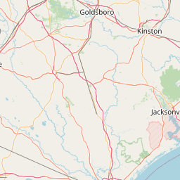
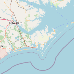
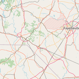

Leaflet | <a href="https://www.openstreetmap.org/copyright">© OpenStreetMap contributors</a>
Item
| Property | Value |
|---|---|
| id | 2398330 |
| downstream_mainstem_id | https://geoconnex.us/ref/mainstems/2398012 |
| encompassing_mainstem_basins | ['https://geoconnex.us/ref/mainstems/2398012'] |
| featuretype | ['https://www.opengis.net/def/schema/hy_features/hyf/HY_FlowPath', 'https://www.opengis.net/def/schema/hy_features/hyf/HY_WaterBody'] |
| fid | 2812 |
| head_2020huc12 | 030202040101 |
| head_nhdpv1_comid | 10976393 |
| head_nhdpv2_comid | https://geoconnex.us/nhdplusv2/comid/10976393 |
| head_nhdpv2huc12 | https://geoconnex.us/nhdplusv2/huc12/030202040101 |
| head_rf1id | 4830 |
| lengthkm | 140.6 |
| name_at_outlet | Trent River |
| name_at_outlet_gnis_id | 1024362 |
| new_mainstemid | |
| outlet_2020huc12 | 030202040305 |
| outlet_drainagearea_sqkm | 1423.4 |
| outlet_nhdpv1_comid | 10977155 |
| outlet_nhdpv2_comid | https://geoconnex.us/nhdplusv2/comid/10977155 |
| outlet_nhdpv2huc12 | https://geoconnex.us/nhdplusv2/huc12/030202040305 |
| outlet_rf1id | 59162 |
| superseded | False |
| uri | https://geoconnex.us/ref/mainstems/2398330 |
Graph Results
| monitoringLocation | https://sta.geoconnex.dev/collections/USGS/Things/items/'USGS-02092500' |
|---|---|
| siteName | USGS-02092500 |
| datasetDescription | Discharge / USGS-02092500-2d47ff6fcb14486fbef2e470061d3006 |
| type | Stream |
| url | https://waterdata.usgs.gov/monitoring-location/02092500/#parameterCode=00060 |
| variableMeasured | Discharge / USGS-02092500-2d47ff6fcb14486fbef2e470061d3006 |
| variableUnit | ft^3/s |
| measurementTechnique | observation |
| temporalCoverage | 2024-08-30T09:15:00Z/2024-09-09T17:45:00Z |
| distributionName | USGS Instantaneous Values Service |
| distributionURL | https://waterservices.usgs.gov/nwis/iv/?sites=USGS:02092500¶meterCd=00060&format=rdb |
| distributionFormat | text/tab-separated-values |
| wkt | POINT (-77.4613888888889 35.0641666666667) |
| monitoringLocation | https://sta.geoconnex.dev/collections/USGS/Things/items/'USGS-02092500' |
|---|---|
| siteName | USGS-02092500 |
| datasetDescription | Discharge / USGS-02092500-2d47ff6fcb14486fbef2e470061d3006 |
| type | Stream |
| url | https://waterdata.usgs.gov/monitoring-location/02092500/#parameterCode=00060 |
| variableMeasured | Discharge / USGS-02092500-2d47ff6fcb14486fbef2e470061d3006 |
| variableUnit | ft^3/s |
| measurementTechnique | observation |
| temporalCoverage | 2024-08-30T09:15:00Z/2024-09-09T17:45:00Z |
| distributionName | USGS SensorThings API |
| distributionURL | https://labs.waterdata.usgs.gov/sta/v1.1/Datastreams('2d47ff6fcb14486fbef2e470061d3006')?$expand=Thing,Observations |
| distributionFormat | application/json |
| wkt | POINT (-77.4613888888889 35.0641666666667) |
| monitoringLocation | https://sta.geoconnex.dev/collections/USGS/Things/items/'USGS-02092500' |
|---|---|
| siteName | USGS-02092500 |
| datasetDescription | Gage height / USGS-02092500-865503321ab24e1a95e4f136b97a63e0 |
| type | Stream |
| url | https://waterdata.usgs.gov/monitoring-location/02092500/#parameterCode=00065 |
| variableMeasured | Gage height / USGS-02092500-865503321ab24e1a95e4f136b97a63e0 |
| variableUnit | ft |
| measurementTechnique | observation |
| temporalCoverage | 2024-08-30T09:15:00Z/2024-09-09T17:45:00Z |
| distributionName | USGS Instantaneous Values Service |
| distributionURL | https://waterservices.usgs.gov/nwis/iv/?sites=USGS:02092500¶meterCd=00065&format=rdb |
| distributionFormat | text/tab-separated-values |
| wkt | POINT (-77.4613888888889 35.0641666666667) |
| monitoringLocation | https://sta.geoconnex.dev/collections/USGS/Things/items/'USGS-02092500' |
|---|---|
| siteName | USGS-02092500 |
| datasetDescription | Gage height / USGS-02092500-865503321ab24e1a95e4f136b97a63e0 |
| type | Stream |
| url | https://waterdata.usgs.gov/monitoring-location/02092500/#parameterCode=00065 |
| variableMeasured | Gage height / USGS-02092500-865503321ab24e1a95e4f136b97a63e0 |
| variableUnit | ft |
| measurementTechnique | observation |
| temporalCoverage | 2024-08-30T09:15:00Z/2024-09-09T17:45:00Z |
| distributionName | USGS SensorThings API |
| distributionURL | https://labs.waterdata.usgs.gov/sta/v1.1/Datastreams('865503321ab24e1a95e4f136b97a63e0')?$expand=Thing,Observations |
| distributionFormat | application/json |
| wkt | POINT (-77.4613888888889 35.0641666666667) |
| monitoringLocation | https://sta.geoconnex.dev/collections/USGS/Things/items/'USGS-02092554' |
|---|---|
| siteName | USGS-02092554 |
| datasetDescription | Gage height / USGS-02092554-104aa5e45ebd49f9883b9bbc59a40c28 |
| type | Stream |
| url | https://waterdata.usgs.gov/monitoring-location/02092554/#parameterCode=00065 |
| variableMeasured | Gage height / USGS-02092554-104aa5e45ebd49f9883b9bbc59a40c28 |
| variableUnit | ft |
| measurementTechnique | observation |
| temporalCoverage | 2024-08-30T09:15:00Z/2024-09-09T18:15:00Z |
| distributionName | USGS SensorThings API |
| distributionURL | https://labs.waterdata.usgs.gov/sta/v1.1/Datastreams('104aa5e45ebd49f9883b9bbc59a40c28')?$expand=Thing,Observations |
| distributionFormat | application/json |
| wkt | POINT (-77.2188888888889 35.01) |
| monitoringLocation | https://sta.geoconnex.dev/collections/USGS/Things/items/'USGS-02092554' |
|---|---|
| siteName | USGS-02092554 |
| datasetDescription | Gage height / USGS-02092554-104aa5e45ebd49f9883b9bbc59a40c28 |
| type | Stream |
| url | https://waterdata.usgs.gov/monitoring-location/02092554/#parameterCode=00065 |
| variableMeasured | Gage height / USGS-02092554-104aa5e45ebd49f9883b9bbc59a40c28 |
| variableUnit | ft |
| measurementTechnique | observation |
| temporalCoverage | 2024-08-30T09:15:00Z/2024-09-09T18:15:00Z |
| distributionName | USGS Instantaneous Values Service |
| distributionURL | https://waterservices.usgs.gov/nwis/iv/?sites=USGS:02092554¶meterCd=00065&format=rdb |
| distributionFormat | text/tab-separated-values |
| wkt | POINT (-77.2188888888889 35.01) |