Beech Branch
Map
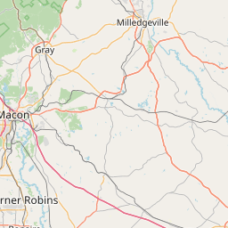
Leaflet | <a href="https://www.openstreetmap.org/copyright">© OpenStreetMap contributors</a>
Item
| Property | Value |
|---|---|
| id | 2451768 |
| downstream_mainstem_id | https://geoconnex.us/ref/mainstems/2451377 |
| encompassing_mainstem_basins | ['https://geoconnex.us/ref/mainstems/2451377'] |
| featuretype | ['https://www.opengis.net/def/schema/hy_features/hyf/HY_FlowPath', 'https://www.opengis.net/def/schema/hy_features/hyf/HY_WaterBody'] |
| fid | 3595 |
| head_2020huc12 | 030502080203 |
| head_nhdpv1_comid | 20152107 |
| head_nhdpv2_comid | https://geoconnex.us/nhdplusv2/comid/20152107 |
| head_nhdpv2huc12 | https://geoconnex.us/nhdplusv2/huc12/030502080203 |
| head_rf1id | 6064 |
| lengthkm | 11.3 |
| name_at_outlet | Beech Branch |
| name_at_outlet_gnis_id | 1245032 |
| new_mainstemid | |
| outlet_2020huc12 | 030502080203 |
| outlet_drainagearea_sqkm | 64.1 |
| outlet_nhdpv1_comid | 20152095 |
| outlet_nhdpv2_comid | https://geoconnex.us/nhdplusv2/comid/20152095 |
| outlet_nhdpv2huc12 | https://geoconnex.us/nhdplusv2/huc12/030502080203 |
| outlet_rf1id | 6064 |
| superseded | False |
| uri | https://geoconnex.us/ref/mainstems/2451768 |