Tomoka River
Map
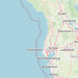
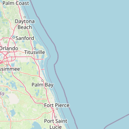

Leaflet | <a href="https://www.openstreetmap.org/copyright">© OpenStreetMap contributors</a>
Item
| Property | Value |
|---|---|
| id | 2507768 |
| downstream_mainstem_id | https://geoconnex.us/ref/mainstems/2507712 |
| encompassing_mainstem_basins | ['https://geoconnex.us/ref/mainstems/2507712'] |
| featuretype | ['https://www.opengis.net/def/schema/hy_features/hyf/HY_FlowPath', 'https://www.opengis.net/def/schema/hy_features/hyf/HY_WaterBody'] |
| fid | 4260 |
| head_2020huc12 | 030802010202 |
| head_nhdpv1_comid | 16687209 |
| head_nhdpv2_comid | https://geoconnex.us/nhdplusv2/comid/16687209 |
| head_nhdpv2huc12 | https://geoconnex.us/nhdplusv2/huc12/030802010202 |
| head_rf1id | None |
| lengthkm | 27.6 |
| name_at_outlet | Tomoka River |
| name_at_outlet_gnis_id | 292346 |
| new_mainstemid | |
| outlet_2020huc12 | 030802010205 |
| outlet_drainagearea_sqkm | 354.2 |
| outlet_nhdpv1_comid | 16687277 |
| outlet_nhdpv2_comid | https://geoconnex.us/nhdplusv2/comid/16687277 |
| outlet_nhdpv2huc12 | https://geoconnex.us/nhdplusv2/huc12/030802010205 |
| outlet_rf1id | None |
| superseded | False |
| uri | https://geoconnex.us/ref/mainstems/2507768 |
Graph Results
| monitoringLocation | https://sta.geoconnex.dev/collections/USGS/Things/items/'USGS-02247510' |
|---|---|
| siteName | USGS-02247510 |
| datasetDescription | Stream water level elevation above NAVD 1988, in feet / USGS-02247510-30d7dd034e9140daa2bfc72aa4f3d7b8 |
| type | Stream |
| url | https://waterdata.usgs.gov/monitoring-location/02247510/#parameterCode=63160 |
| variableMeasured | Stream water level elevation above NAVD 1988 |
| variableUnit | ft |
| measurementTechnique | observation |
| temporalCoverage | 2024-08-30T09:15:00Z/2024-09-09T18:30:00Z |
| distributionName | USGS Instantaneous Values Service |
| distributionURL | https://waterservices.usgs.gov/nwis/iv/?sites=USGS:02247510¶meterCd=63160&format=rdb |
| distributionFormat | text/tab-separated-values |
| wkt | POINT (-81.108668711557 29.217480987732) |
| monitoringLocation | https://sta.geoconnex.dev/collections/USGS/Things/items/'USGS-02247510' |
|---|---|
| siteName | USGS-02247510 |
| datasetDescription | Stream water level elevation above NAVD 1988, in feet / USGS-02247510-30d7dd034e9140daa2bfc72aa4f3d7b8 |
| type | Stream |
| url | https://waterdata.usgs.gov/monitoring-location/02247510/#parameterCode=63160 |
| variableMeasured | Stream water level elevation above NAVD 1988 |
| variableUnit | ft |
| measurementTechnique | observation |
| temporalCoverage | 2024-08-30T09:15:00Z/2024-09-09T18:30:00Z |
| distributionName | USGS SensorThings API |
| distributionURL | https://labs.waterdata.usgs.gov/sta/v1.1/Datastreams('30d7dd034e9140daa2bfc72aa4f3d7b8')?$expand=Thing,Observations |
| distributionFormat | application/json |
| wkt | POINT (-81.108668711557 29.217480987732) |
| monitoringLocation | https://sta.geoconnex.dev/collections/USGS/Things/items/'USGS-02247510' |
|---|---|
| siteName | USGS-02247510 |
| datasetDescription | Gage height / USGS-02247510-437f7a0ddcac4e81b0c688a0921fa9eb |
| type | Stream |
| url | https://waterdata.usgs.gov/monitoring-location/02247510/#parameterCode=00065 |
| variableMeasured | Gage height / USGS-02247510-437f7a0ddcac4e81b0c688a0921fa9eb |
| variableUnit | ft |
| measurementTechnique | observation |
| temporalCoverage | 2024-08-30T09:15:00Z/2024-09-09T18:30:00Z |
| distributionName | USGS Instantaneous Values Service |
| distributionURL | https://waterservices.usgs.gov/nwis/iv/?sites=USGS:02247510¶meterCd=00065&format=rdb |
| distributionFormat | text/tab-separated-values |
| wkt | POINT (-81.108668711557 29.217480987732) |
| monitoringLocation | https://sta.geoconnex.dev/collections/USGS/Things/items/'USGS-02247510' |
|---|---|
| siteName | USGS-02247510 |
| datasetDescription | Gage height / USGS-02247510-437f7a0ddcac4e81b0c688a0921fa9eb |
| type | Stream |
| url | https://waterdata.usgs.gov/monitoring-location/02247510/#parameterCode=00065 |
| variableMeasured | Gage height / USGS-02247510-437f7a0ddcac4e81b0c688a0921fa9eb |
| variableUnit | ft |
| measurementTechnique | observation |
| temporalCoverage | 2024-08-30T09:15:00Z/2024-09-09T18:30:00Z |
| distributionName | USGS SensorThings API |
| distributionURL | https://labs.waterdata.usgs.gov/sta/v1.1/Datastreams('437f7a0ddcac4e81b0c688a0921fa9eb')?$expand=Thing,Observations |
| distributionFormat | application/json |
| wkt | POINT (-81.108668711557 29.217480987732) |
| monitoringLocation | https://sta.geoconnex.dev/collections/USGS/Things/items/'USGS-02247510' |
|---|---|
| siteName | USGS-02247510 |
| datasetDescription | Discharge / USGS-02247510-a0abc274e4ba4362a44f085dfe260416 |
| type | Stream |
| url | https://waterdata.usgs.gov/monitoring-location/02247510/#parameterCode=00060 |
| variableMeasured | Discharge / USGS-02247510-a0abc274e4ba4362a44f085dfe260416 |
| variableUnit | ft^3/s |
| measurementTechnique | observation |
| temporalCoverage | 2024-08-30T09:15:00Z/2024-09-09T18:30:00Z |
| distributionName | USGS Instantaneous Values Service |
| distributionURL | https://waterservices.usgs.gov/nwis/iv/?sites=USGS:02247510¶meterCd=00060&format=rdb |
| distributionFormat | text/tab-separated-values |
| wkt | POINT (-81.108668711557 29.217480987732) |
| monitoringLocation | https://sta.geoconnex.dev/collections/USGS/Things/items/'USGS-02247510' |
|---|---|
| siteName | USGS-02247510 |
| datasetDescription | Discharge / USGS-02247510-a0abc274e4ba4362a44f085dfe260416 |
| type | Stream |
| url | https://waterdata.usgs.gov/monitoring-location/02247510/#parameterCode=00060 |
| variableMeasured | Discharge / USGS-02247510-a0abc274e4ba4362a44f085dfe260416 |
| variableUnit | ft^3/s |
| measurementTechnique | observation |
| temporalCoverage | 2024-08-30T09:15:00Z/2024-09-09T18:30:00Z |
| distributionName | USGS SensorThings API |
| distributionURL | https://labs.waterdata.usgs.gov/sta/v1.1/Datastreams('a0abc274e4ba4362a44f085dfe260416')?$expand=Thing,Observations |
| distributionFormat | application/json |
| wkt | POINT (-81.108668711557 29.217480987732) |