Tenmile Creek
Map
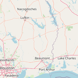
Leaflet | <a href="https://www.openstreetmap.org/copyright">© OpenStreetMap contributors</a>
Item
| Property | Value |
|---|---|
| id | 2603729 |
| downstream_mainstem_id | https://geoconnex.us/ref/mainstems/2602412 |
| encompassing_mainstem_basins | ['https://geoconnex.us/ref/mainstems/2602412'] |
| featuretype | ['https://www.opengis.net/def/schema/hy_features/hyf/HY_FlowPath', 'https://www.opengis.net/def/schema/hy_features/hyf/HY_WaterBody'] |
| fid | 22766 |
| head_2020huc12 | 120200030403 |
| head_nhdpv1_comid | 1113923 |
| head_nhdpv2_comid | https://geoconnex.us/nhdplusv2/comid/1113923 |
| head_nhdpv2huc12 | https://geoconnex.us/nhdplusv2/huc12/120200030403 |
| head_rf1id | None |
| lengthkm | 41.3 |
| name_at_outlet | Tenmile Creek |
| name_at_outlet_gnis_id | 1348361 |
| new_mainstemid | |
| outlet_2020huc12 | 120200030403 |
| outlet_drainagearea_sqkm | 221.6 |
| outlet_nhdpv1_comid | 1114361 |
| outlet_nhdpv2_comid | https://geoconnex.us/nhdplusv2/comid/1114361 |
| outlet_nhdpv2huc12 | https://geoconnex.us/nhdplusv2/huc12/120200030403 |
| outlet_rf1id | None |
| superseded | False |
| uri | https://geoconnex.us/ref/mainstems/2603729 |
Graph Results
| monitoringLocation | https://sta.geoconnex.dev/collections/USGS/Things/items/'USGS-08041788' |
|---|---|
| siteName | USGS-08041788 |
| datasetDescription | Gage height / USGS-08041788-9dd6a22ac2be4a5d89f24411f18ff8cf |
| type | Stream |
| url | https://waterdata.usgs.gov/monitoring-location/08041788/#parameterCode=00065 |
| variableMeasured | Gage height / USGS-08041788-9dd6a22ac2be4a5d89f24411f18ff8cf |
| variableUnit | ft |
| measurementTechnique | observation |
| temporalCoverage | 2024-08-30T09:05:00Z/2024-09-09T16:30:00Z |
| distributionName | USGS SensorThings API |
| distributionURL | https://labs.waterdata.usgs.gov/sta/v1.1/Datastreams('9dd6a22ac2be4a5d89f24411f18ff8cf')?$expand=Thing,Observations |
| distributionFormat | application/json |
| wkt | POINT (-94.07677222222222 30.09553888888889) |
| monitoringLocation | https://sta.geoconnex.dev/collections/USGS/Things/items/'USGS-08041788' |
|---|---|
| siteName | USGS-08041788 |
| datasetDescription | Gage height / USGS-08041788-9dd6a22ac2be4a5d89f24411f18ff8cf |
| type | Stream |
| url | https://waterdata.usgs.gov/monitoring-location/08041788/#parameterCode=00065 |
| variableMeasured | Gage height / USGS-08041788-9dd6a22ac2be4a5d89f24411f18ff8cf |
| variableUnit | ft |
| measurementTechnique | observation |
| temporalCoverage | 2024-08-30T09:05:00Z/2024-09-09T16:30:00Z |
| distributionName | USGS Instantaneous Values Service |
| distributionURL | https://waterservices.usgs.gov/nwis/iv/?sites=USGS:08041788¶meterCd=00065&format=rdb |
| distributionFormat | text/tab-separated-values |
| wkt | POINT (-94.07677222222222 30.09553888888889) |