White River
Map
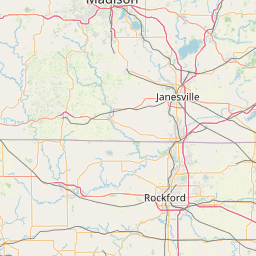
Leaflet | <a href="https://www.openstreetmap.org/copyright">© OpenStreetMap contributors</a>
Item
| Property | Value |
|---|---|
| id | 422430 |
| downstream_mainstem_id | https://geoconnex.us/ref/mainstems/341500 |
| encompassing_mainstem_basins | ['https://geoconnex.us/ref/mainstems/341500', 'https://geoconnex.us/ref/mainstems/324005', 'https://geoconnex.us/ref/mainstems/312091'] |
| featuretype | ['https://www.opengis.net/def/schema/hy_features/hyf/HY_FlowPath', 'https://www.opengis.net/def/schema/hy_features/hyf/HY_WaterBody'] |
| fid | 12211 |
| head_2020huc12 | 071200060602 |
| head_nhdpv1_comid | 14768748 |
| head_nhdpv2_comid | https://geoconnex.us/nhdplusv2/comid/14768748 |
| head_nhdpv2huc12 | https://geoconnex.us/nhdplusv2/huc12/071200060602 |
| head_rf1id | 19783 |
| lengthkm | 42.0 |
| name_at_outlet | White River |
| name_at_outlet_gnis_id | 1576654 |
| new_mainstemid | |
| outlet_2020huc12 | 071200060604 |
| outlet_drainagearea_sqkm | 691.8 |
| outlet_nhdpv1_comid | 14769392 |
| outlet_nhdpv2_comid | https://geoconnex.us/nhdplusv2/comid/14769392 |
| outlet_nhdpv2huc12 | https://geoconnex.us/nhdplusv2/huc12/071200060604 |
| outlet_rf1id | 19777 |
| superseded | False |
| uri | https://geoconnex.us/ref/mainstems/422430 |
Graph Results
| monitoringLocation | https://sta.geoconnex.dev/collections/USGS/Things/items/'USGS-055451345' |
|---|---|
| siteName | USGS-055451345 |
| datasetDescription | Gage height / USGS-055451345-10dc08bb2afd48ed98c0099cee66c9b5 |
| type | Stream |
| url | https://waterdata.usgs.gov/monitoring-location/055451345/#parameterCode=00065 |
| variableMeasured | Gage height / USGS-055451345-10dc08bb2afd48ed98c0099cee66c9b5 |
| variableUnit | ft |
| measurementTechnique | observation |
| temporalCoverage | 2024-08-30T09:05:00Z/2024-09-07T22:40:00Z |
| distributionName | USGS Instantaneous Values Service |
| distributionURL | https://waterservices.usgs.gov/nwis/iv/?sites=USGS:055451345¶meterCd=00065&format=rdb |
| distributionFormat | text/tab-separated-values |
| wkt | POINT (-88.4336111111111 42.5905555555556) |
| monitoringLocation | https://sta.geoconnex.dev/collections/USGS/Things/items/'USGS-055451345' |
|---|---|
| siteName | USGS-055451345 |
| datasetDescription | Gage height / USGS-055451345-10dc08bb2afd48ed98c0099cee66c9b5 |
| type | Stream |
| url | https://waterdata.usgs.gov/monitoring-location/055451345/#parameterCode=00065 |
| variableMeasured | Gage height / USGS-055451345-10dc08bb2afd48ed98c0099cee66c9b5 |
| variableUnit | ft |
| measurementTechnique | observation |
| temporalCoverage | 2024-08-30T09:05:00Z/2024-09-07T22:40:00Z |
| distributionName | USGS SensorThings API |
| distributionURL | https://labs.waterdata.usgs.gov/sta/v1.1/Datastreams('10dc08bb2afd48ed98c0099cee66c9b5')?$expand=Thing,Observations |
| distributionFormat | application/json |
| wkt | POINT (-88.4336111111111 42.5905555555556) |
| monitoringLocation | https://sta.geoconnex.dev/collections/USGS/Things/items/'USGS-055451345' |
|---|---|
| siteName | USGS-055451345 |
| datasetDescription | Stream water level elevation above NAVD 1988 in feet / USGS-055451345-efa7dee48cf64780b5f79f354f2804d6 |
| type | Stream |
| url | https://waterdata.usgs.gov/monitoring-location/055451345/#parameterCode=63160 |
| variableMeasured | Stream water level elevation above NAVD 1988 |
| variableUnit | ft |
| measurementTechnique | observation |
| temporalCoverage | 2024-08-30T09:05:00Z/2024-09-07T22:40:00Z |
| distributionName | USGS Instantaneous Values Service |
| distributionURL | https://waterservices.usgs.gov/nwis/iv/?sites=USGS:055451345¶meterCd=63160&format=rdb |
| distributionFormat | text/tab-separated-values |
| wkt | POINT (-88.4336111111111 42.5905555555556) |
| monitoringLocation | https://sta.geoconnex.dev/collections/USGS/Things/items/'USGS-055451345' |
|---|---|
| siteName | USGS-055451345 |
| datasetDescription | Stream water level elevation above NAVD 1988 in feet / USGS-055451345-efa7dee48cf64780b5f79f354f2804d6 |
| type | Stream |
| url | https://waterdata.usgs.gov/monitoring-location/055451345/#parameterCode=63160 |
| variableMeasured | Stream water level elevation above NAVD 1988 |
| variableUnit | ft |
| measurementTechnique | observation |
| temporalCoverage | 2024-08-30T09:05:00Z/2024-09-07T22:40:00Z |
| distributionName | USGS SensorThings API |
| distributionURL | https://labs.waterdata.usgs.gov/sta/v1.1/Datastreams('efa7dee48cf64780b5f79f354f2804d6')?$expand=Thing,Observations |
| distributionFormat | application/json |
| wkt | POINT (-88.4336111111111 42.5905555555556) |
| monitoringLocation | https://sta.geoconnex.dev/collections/USGS/Things/items/'USGS-055451345' |
|---|---|
| siteName | USGS-055451345 |
| datasetDescription | Discharge / USGS-055451345-636318297b4f4965ab95e46acc68f2cb |
| type | Stream |
| url | https://waterdata.usgs.gov/monitoring-location/055451345/#parameterCode=00060 |
| variableMeasured | Discharge / USGS-055451345-636318297b4f4965ab95e46acc68f2cb |
| variableUnit | ft^3/s |
| measurementTechnique | observation |
| temporalCoverage | 2024-08-30T09:05:00Z/2024-09-06T12:55:00Z |
| distributionName | USGS Instantaneous Values Service |
| distributionURL | https://waterservices.usgs.gov/nwis/iv/?sites=USGS:055451345¶meterCd=00060&format=rdb |
| distributionFormat | text/tab-separated-values |
| wkt | POINT (-88.4336111111111 42.5905555555556) |
| monitoringLocation | https://sta.geoconnex.dev/collections/USGS/Things/items/'USGS-055451345' |
|---|---|
| siteName | USGS-055451345 |
| datasetDescription | Discharge / USGS-055451345-636318297b4f4965ab95e46acc68f2cb |
| type | Stream |
| url | https://waterdata.usgs.gov/monitoring-location/055451345/#parameterCode=00060 |
| variableMeasured | Discharge / USGS-055451345-636318297b4f4965ab95e46acc68f2cb |
| variableUnit | ft^3/s |
| measurementTechnique | observation |
| temporalCoverage | 2024-08-30T09:05:00Z/2024-09-06T12:55:00Z |
| distributionName | USGS SensorThings API |
| distributionURL | https://labs.waterdata.usgs.gov/sta/v1.1/Datastreams('636318297b4f4965ab95e46acc68f2cb')?$expand=Thing,Observations |
| distributionFormat | application/json |
| wkt | POINT (-88.4336111111111 42.5905555555556) |