Snake Creek
Map


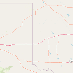

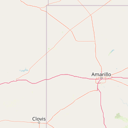

Leaflet | <a href="https://www.openstreetmap.org/copyright">© OpenStreetMap contributors</a>
Item
| Property | Value |
|---|---|
| id | 425917 |
| downstream_mainstem_id | https://geoconnex.us/ref/mainstems/314446 |
| encompassing_mainstem_basins | ['https://geoconnex.us/ref/mainstems/314446', 'https://geoconnex.us/ref/mainstems/312091'] |
| featuretype | ['https://www.opengis.net/def/schema/hy_features/hyf/HY_FlowPath', 'https://www.opengis.net/def/schema/hy_features/hyf/HY_WaterBody'] |
| fid | 21520 |
| head_2020huc12 | 111101010204 |
| head_nhdpv1_comid | 370339 |
| head_nhdpv2_comid | https://geoconnex.us/nhdplusv2/comid/370339 |
| head_nhdpv2huc12 | https://geoconnex.us/nhdplusv2/huc12/111101010204 |
| head_rf1id | 35770 |
| lengthkm | 53.9 |
| name_at_outlet | Snake Creek |
| name_at_outlet_gnis_id | 1098146 |
| new_mainstemid | |
| outlet_2020huc12 | 111101010207 |
| outlet_drainagearea_sqkm | 488.0 |
| outlet_nhdpv1_comid | 371189 |
| outlet_nhdpv2_comid | https://geoconnex.us/nhdplusv2/comid/371189 |
| outlet_nhdpv2huc12 | https://geoconnex.us/nhdplusv2/huc12/111101010207 |
| outlet_rf1id | 35768 |
| superseded | False |
| uri | https://geoconnex.us/ref/mainstems/425917 |