Item 426046
Map


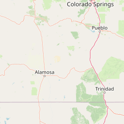

Leaflet | <a href="https://www.openstreetmap.org/copyright">© OpenStreetMap contributors</a>
Item
| Property | Value |
|---|---|
| id | 426046 |
| downstream_mainstem_id | https://geoconnex.us/ref/mainstems/557204 |
| encompassing_mainstem_basins | ['https://geoconnex.us/ref/mainstems/557204', 'https://geoconnex.us/ref/mainstems/314446', 'https://geoconnex.us/ref/mainstems/312091'] |
| featuretype | ['https://www.opengis.net/def/schema/hy_features/hyf/HY_FlowPath', 'https://www.opengis.net/def/schema/hy_features/hyf/HY_WaterBody'] |
| fid | 20651 |
| head_2020huc12 | 110600040401 |
| head_nhdpv1_comid | 20999697 |
| head_nhdpv2_comid | https://geoconnex.us/nhdplusv2/comid/20999697 |
| head_nhdpv2huc12 | https://geoconnex.us/nhdplusv2/huc12/110600040401 |
| head_rf1id | 34955 |
| lengthkm | 60.6 |
| name_at_outlet | |
| name_at_outlet_gnis_id | None |
| new_mainstemid | |
| outlet_2020huc12 | 110600040407 |
| outlet_drainagearea_sqkm | 622.3 |
| outlet_nhdpv1_comid | 21002239 |
| outlet_nhdpv2_comid | https://geoconnex.us/nhdplusv2/comid/21002239 |
| outlet_nhdpv2huc12 | https://geoconnex.us/nhdplusv2/huc12/110600040407 |
| outlet_rf1id | 34953 |
| superseded | False |
| uri | https://geoconnex.us/ref/mainstems/426046 |