Lukachukai Creek
Map
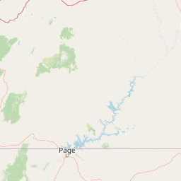
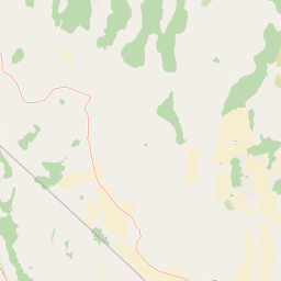

Leaflet | <a href="https://www.openstreetmap.org/copyright">© OpenStreetMap contributors</a>
Item
| Property | Value |
|---|---|
| id | 43788 |
| downstream_mainstem_id | https://geoconnex.us/ref/mainstems/36613 |
| encompassing_mainstem_basins | ['https://geoconnex.us/ref/mainstems/36613', 'https://geoconnex.us/ref/mainstems/31552', 'https://geoconnex.us/ref/mainstems/29559'] |
| featuretype | ['https://www.opengis.net/def/schema/hy_features/hyf/HY_FlowPath', 'https://www.opengis.net/def/schema/hy_features/hyf/HY_WaterBody'] |
| fid | 26499 |
| head_2020huc12 | 140802041003 |
| head_nhdpv1_comid | 1409053 |
| head_nhdpv2_comid | https://geoconnex.us/nhdplusv2/comid/1409053 |
| head_nhdpv2huc12 | https://geoconnex.us/nhdplusv2/huc12/140802041003 |
| head_rf1id | 43013 |
| lengthkm | 65.9 |
| name_at_outlet | Lukachukai Creek |
| name_at_outlet_gnis_id | 417 |
| new_mainstemid | |
| outlet_2020huc12 | 140802041012 |
| outlet_drainagearea_sqkm | 1153.2 |
| outlet_nhdpv1_comid | 1407697 |
| outlet_nhdpv2_comid | https://geoconnex.us/nhdplusv2/comid/1407697 |
| outlet_nhdpv2huc12 | https://geoconnex.us/nhdplusv2/huc12/140802041012 |
| outlet_rf1id | 43011 |
| superseded | False |
| uri | https://geoconnex.us/ref/mainstems/43788 |