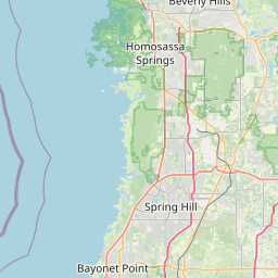
HERNANDO CO UTL-EAST
Map


Leaflet | <a href="https://www.openstreetmap.org/copyright">© OpenStreetMap contributors</a>
Item
| Property | Value |
|---|---|
| id | FL6277060 |
| boundary_type | Unknown Service Area - Using EPA ECHO facility location with buffered radius to represent PWS |
| centroid_lat | 28.5165785 |
| centroid_lon | -82.4046645 |
| centroid_quality | TIGER: CALCULATED FROM GEOMETRY |
| city_served | BROOKSVILLE |
| contact_email | jess@gosimplelab.com |
| contribution_date | 2022-07-05 |
| county_served | HERNANDO |
| data_source | SimpleLab |
| fid | 9498 |
| is_wholesaler_ind | False |
| owner_type_code | L |
| place_uri | https://geoconnex.us/ref/places/ |
| population_served_count | 8469 |
| pred_05 | 3409.96228285291 |
| pred_50 | 3654.7758961373 |
| pred_95 | 3917.16557046809 |
| primacy_agency_code | FL |
| primacy_type | State |
| primary_source_code | GW |
| primary_water_source | Groundwater |
| pws_name | HERNANDO CO UTL-EAST |
| sdwis_link | https://enviro.epa.gov/enviro/sdw_report_v3.first_table?pws_id=FL6277060&state=FL&source=0&population=0 |
| service_area_type | Other Area |
| service_connections_count | 3798 |
| source_date | 2022-07-05 |
| source_url | https://www.hydroshare.org/resource/b11b8982eebd4843833932f085f71d92/data/contents/temm.geojson |
| state_code | FL |
| state_uri | https://geoconnex.us/ref/states/12 |
| tier | 3 |
| uri | https://geoconnex.us/ref/pws/FL6277060 |
| wholesaler | Is not a wholesaler |