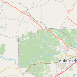
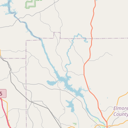
USGS NWIS Stream/River/Lake Site 02418760: CHEWACLA CREEK AT CHEWACLA STATE PARK NR AUBURN
Map

Leaflet | <a href="https://www.openstreetmap.org/copyright">© OpenStreetMap contributors</a>
Item
| Property | Value |
|---|---|
| id | 1055733 |
| cluster | None |
| dasqkm_diff | 1.5 |
| description | USGS NWIS Stream/River/Lake Site 02418760: CHEWACLA CREEK AT CHEWACLA STATE PARK NR AUBURN |
| fid | 184158 |
| gage_totdasqkm | 118.6 |
| mainstem_uri | https://geoconnex.us/ref/mainstems/1701778 |
| name | CHEWACLA CREEK AT CHEWACLA STATE PARK NR AUBURN |
| nhdpv2_comid | 21712732.0 |
| nhdpv2_link_source | https://www.epa.gov/waterdata/nhdplus-national-hydrography-dataset-plus |
| nhdpv2_offset_m | 22.1044144917362 |
| nhdpv2_reach_measure | 65.85919 |
| nhdpv2_reachcode | 03150110000307 |
| nhdpv2_totdasqkm | 120.1 |
| provider | https://waterdata.usgs.gov |
| provider_id | 02418760 |
| subjectof | https://waterdata.usgs.gov/monitoring-location/02418760 |
| uri | https://geoconnex.us/ref/gages/1055733 |