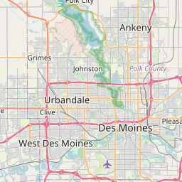
USGS NWIS Stream/River/Lake Site 0548560290: Fourmile Creek 275 ft u/s of Outfall nr Ankeny, IA
Map


Leaflet | <a href="https://www.openstreetmap.org/copyright">© OpenStreetMap contributors</a>
Item
| Property | Value |
|---|---|
| id | 1063153 |
| cluster | https://geoconnex.us/ref/gages/1063132,https://geoconnex.us/ref/gages/1063154 |
| dasqkm_diff | 11.3 |
| description | USGS NWIS Stream/River/Lake Site 0548560290: Fourmile Creek 275 ft u/s of Outfall nr Ankeny, IA |
| fid | 54987 |
| gage_totdasqkm | 154.6 |
| mainstem_uri | https://geoconnex.us/ref/mainstems/427762 |
| name | Fourmile Creek 275 ft u/s of Outfall nr Ankeny, IA |
| nhdpv2_comid | 22248777.0 |
| nhdpv2_link_source | https://github.com/internetofwater/ref_gages |
| nhdpv2_offset_m | 19.4106939031337 |
| nhdpv2_reach_measure | 98.1519 |
| nhdpv2_reachcode | 07100008000091 |
| nhdpv2_totdasqkm | 165.9 |
| nws_url | None |
| provider | https://waterdata.usgs.gov |
| provider_id | 0548560290 |
| subjectof | https://waterdata.usgs.gov/monitoring-location/0548560290 |
| uri | https://geoconnex.us/ref/gages/1063153 |