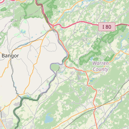
USGS NWIS Stream/River/Lake Site 404829074592840: Furnace Brook .3 mi N of Oxford, NJ
Map


Leaflet | <a href="https://www.openstreetmap.org/copyright">© OpenStreetMap contributors</a>
Item
| Property | Value |
|---|---|
| id | 1147071 |
| cluster | None |
| dasqkm_diff | None |
| description | USGS NWIS Stream/River/Lake Site 404829074592840: Furnace Brook .3 mi N of Oxford, NJ |
| fid | 135443 |
| gage_totdasqkm | None |
| mainstem_uri | None |
| name | Furnace Brook .3 mi N of Oxford, NJ |
| nhdpv2_comid | 2586453.0 |
| nhdpv2_link_source | https://github.com/internetofwater/ref_gages |
| nhdpv2_offset_m | 160.854172529114 |
| nhdpv2_reach_measure | 55.9343 |
| nhdpv2_reachcode | 02040105000816 |
| nhdpv2_totdasqkm | 12.0 |
| nws_url | None |
| provider | https://waterdata.usgs.gov |
| provider_id | 404829074592840 |
| subjectof | https://waterdata.usgs.gov/monitoring-location/404829074592840 |
| uri | https://geoconnex.us/ref/gages/1147071 |