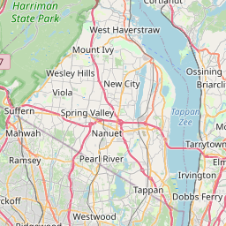
USGS NWIS Stream/River/Lake Site 405758073522000: SAW MILL RIVER AT O DELL AVE ABOVE YONKERS NY
Map


Leaflet | <a href="https://www.openstreetmap.org/copyright">© OpenStreetMap contributors</a>
Item
| Property | Value |
|---|---|
| id | 1151982 |
| cluster | https://geoconnex.us/ref/gages/1150218 |
| dasqkm_diff | None |
| description | USGS NWIS Stream/River/Lake Site 405758073522000: SAW MILL RIVER AT O DELL AVE ABOVE YONKERS NY |
| fid | 140284 |
| gage_totdasqkm | None |
| mainstem_uri | https://geoconnex.us/ref/mainstems/2108408 |
| name | SAW MILL RIVER AT O DELL AVE ABOVE YONKERS NY |
| nhdpv2_comid | 932030061.0 |
| nhdpv2_link_source | https://github.com/internetofwater/ref_gages |
| nhdpv2_offset_m | 31.147854869297 |
| nhdpv2_reach_measure | 35.4533 |
| nhdpv2_reachcode | 02030101000128 |
| nhdpv2_totdasqkm | 67.6 |
| nws_url | None |
| provider | https://waterdata.usgs.gov |
| provider_id | 405758073522000 |
| subjectof | https://waterdata.usgs.gov/monitoring-location/405758073522000 |
| uri | https://geoconnex.us/ref/gages/1151982 |