/
https://geoconnex.us/ref/hu08/18040051
JSON
JSON-LD
Resources
Collections
Sitemap
Processes
Documentation
Geoconnex Docs
API Definition
Conformance
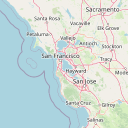
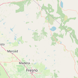
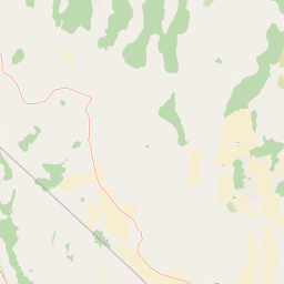
Rock Creek-French Camp Slough
Map
+
−
Leaflet
| <a href="https://www.openstreetmap.org/copyright">© OpenStreetMap contributors</a>
Previous
Next
Item
Property
Value
id
18040051
fid
816
gnis_id
None
gnis_url
hucs
https://geoconnex.us/ref/hu10/1804005101
https://geoconnex.us/ref/hu10/1804005102
https://geoconnex.us/ref/hu10/1804005104
https://geoconnex.us/ref/hu10/1804005103
https://geoconnex.us/iow/wqp/CALWR_WQX-01N08E10C001M
https://geoconnex.us/iow/wqp/CALWR_WQX-01N09E26A001M
https://geoconnex.us/iow/wqp/CALWR_WQX-01N06E13B003M
https://geoconnex.us/iow/wqp/CEDEN-531SJC201
https://geoconnex.us/iow/wqp/CEDEN-531XLCAER
https://geoconnex.us/iow/wqp/USGS-375429121124501
https://geoconnex.us/iow/wqp/USGS-375126120493001
https://geoconnex.us/iow/wqp/CALWR_WQX-02S08E02C001M
https://geoconnex.us/iow/wqp/CEDEN-531XDCAHF
https://geoconnex.us/iow/wqp/USGS-374724120575901
https://geoconnex.us/iow/wqp/CEDEN-531XLTCJR
https://geoconnex.us/iow/wqp/CALWR_WQX-01N07E17P001M
https://geoconnex.us/iow/wqp/CALWR_WQX-01N07E26H003M
https://geoconnex.us/iow/wqp/CALWR_WQX-01N08E15J001M
https://geoconnex.us/iow/wqp/CEDEN-535PS0477
https://geoconnex.us/iow/wqp/USGS-375641120563801
https://geoconnex.us/iow/wqp/USGS-374900120540002
https://geoconnex.us/iow/wqp/USGS-375303120580801
https://geoconnex.us/iow/wqp/USGS-375559120564401
https://geoconnex.us/iow/wqp/USGS-374944120555601
https://geoconnex.us/iow/wqp/CEDEN-535BLATMR
https://geoconnex.us/iow/wqp/USGS-375400121110001
https://geoconnex.us/iow/wqp/USGS-375003121121901
https://geoconnex.us/iow/wqp/USGS-375718121050501
https://geoconnex.us/iow/wqp/CALWR_WQX-01N09E16F001M
https://geoconnex.us/iow/wqp/USGS-375142120564001
https://geoconnex.us/iow/wqp/USGS-375440121081401
https://geoconnex.us/iow/wqp/CEDEN-531STC212
https://geoconnex.us/iow/wqp/USGS-374753121070001
https://geoconnex.us/iow/wqp/CALWR_WQX-01S07E10A001M
https://geoconnex.us/iow/wqp/CALWR_WQX-01S09E33P001M
https://geoconnex.us/iow/wqp/USGS-374900120540001
https://geoconnex.us/iow/wqp/CEDEN-531LCATMR
https://geoconnex.us/iow/wqp/CEDEN-WK-64R
https://geoconnex.us/iow/wqp/USGS-374845121093901
https://geoconnex.us/iow/wqp/USGS-375345121060801
https://geoconnex.us/iow/wqp/CEDEN-535OAKSWL
https://geoconnex.us/iow/wqp/USGS-374824120503001
https://geoconnex.us/iow/wqp/USGS-375621121154001
https://geoconnex.us/iow/wqp/USGS-375035120593401
https://geoconnex.us/iow/wqp/USGS-375350121042001
https://geoconnex.us/iow/wqp/USGS-374932121083301
https://geoconnex.us/iow/wqp/USGS-375623120484701
https://geoconnex.us/iow/wqp/USGS-375339121150301
https://geoconnex.us/iow/wqp/USGS-375349121160901
https://geoconnex.us/iow/wqp/USGS-375551120580301
https://geoconnex.us/iow/wqp/USGS-375622120593201
https://geoconnex.us/iow/wqp/USGS-375453120565001
https://geoconnex.us/iow/wqp/USGS-375031121053001
https://geoconnex.us/iow/wqp/USGS-374618121051701
https://geoconnex.us/iow/wqp/USGS-374902121031101
https://geoconnex.us/iow/wqp/USGS-375349121160903
https://geoconnex.us/iow/wqp/USGS-375053121030601
https://geoconnex.us/iow/wqp/USGS-375539121140001
https://geoconnex.us/iow/wqp/USGS-375545121141601
https://geoconnex.us/iow/wqp/USGS-374940121034701
https://geoconnex.us/iow/wqp/CEDEN-531UDLTAJ
https://geoconnex.us/iow/wqp/CALWR_WQX-01S07E21G001M
https://geoconnex.us/iow/wqp/CEDEN-531SJC504
https://geoconnex.us/iow/wqp/USGS-374939121042101
https://geoconnex.us/iow/wqp/USGS-375326121145901
https://geoconnex.us/iow/wqp/USGS-374717120580401
https://geoconnex.us/iow/wqp/USGS-375320121160801
https://geoconnex.us/iow/wqp/USGS-375643121091901
https://geoconnex.us/iow/wqp/USGS-374749121035001
https://geoconnex.us/iow/wqp/USGS-375020120584101
https://geoconnex.us/iow/wqp/USGS-375349121160902
https://geoconnex.us/iow/wqp/USGS-375602121043101
https://geoconnex.us/iow/wqp/USGS-375026121100001
https://geoconnex.us/iow/wqp/USGS-375701121065701
https://geoconnex.us/iow/wqp/USGS-375517121144701
https://geoconnex.us/iow/wqp/USGS-374736121083401
https://geoconnex.us/iow/wqp/CEDEN-531PS0429
https://geoconnex.us/iow/wqp/USGS-375019120520201
https://geoconnex.us/iow/wqp/USGS-375701121132101
https://geoconnex.us/iow/wqp/USGS-375514120595801
https://geoconnex.us/iow/wqp/USGS-374618120580001
https://geoconnex.us/iow/wqp/USGS-375624121151901
https://geoconnex.us/iow/wqp/CALWR_WQX-01S09E11J002M
https://geoconnex.us/iow/wqp/CEDEN-531DEL503
https://geoconnex.us/iow/wqp/CEDEN-531PS0365
https://geoconnex.us/iow/wqp/CEDEN-535XLTABR
https://geoconnex.us/iow/wqp/USGS-374753120590401
https://geoconnex.us/iow/wqp/USGS-375241121031101
https://geoconnex.us/iow/wqp/USGS-374552121015701
https://geoconnex.us/iow/wqp/USGS-374756120591701
https://geoconnex.us/iow/wqp/USGS-374900120520001
https://geoconnex.us/iow/wqp/CEDEN-531XSED08
https://geoconnex.us/iow/wqp/USGS-375120121110300
https://geoconnex.us/iow/wqp/USGS-375452121141401
https://geoconnex.us/iow/wqp/USGS-374817120562801
https://geoconnex.us/iow/wqp/CEDEN-DC-65R
https://geoconnex.us/iow/wqp/USGS-374658121030001
https://geoconnex.us/iow/wqp/USGS-375337121120601
https://geoconnex.us/iow/wqp/USGS-375001120541101
https://geoconnex.us/iow/wqp/USGS-375252121145401
https://geoconnex.us/iow/wqp/CEDEN-531SJC503
https://geoconnex.us/iow/wqp/CALWR_WQX-01S08E13M001M
https://geoconnex.us/iow/wqp/USGS-375555121125401
https://geoconnex.us/iow/wqp/CEDEN-535LTCVHR
https://geoconnex.us/iow/wqp/OST_SHPD-1002
https://geoconnex.us/iow/wqp/USGS-375706121130301
https://geoconnex.us/iow/wqp/USGS-375500121000001
https://geoconnex.us/iow/wqp/USGS-375321120571801
https://geoconnex.us/iow/wqp/USGS-375345121045801
https://geoconnex.us/iow/wqp/USGS-374718121041401
https://geoconnex.us/iow/wqp/USGS-374730121035401
https://geoconnex.us/iow/wqp/USGS-375100121020001
https://geoconnex.us/iow/wqp/USGS-375510121031301
https://geoconnex.us/iow/wqp/USGS-375219121004801
https://geoconnex.us/iow/wqp/USGS-374902121015901
https://geoconnex.us/iow/wqp/CALWR_WQX-01S09E16P002M
https://geoconnex.us/iow/wqp/CALWR_WQX-01S08E16R001M
https://geoconnex.us/iow/wqp/USGS-375422121095301
https://geoconnex.us/iow/wqp/USGS-374610120552801
https://geoconnex.us/iow/wqp/USGS-374700120580001
https://geoconnex.us/iow/wqp/USGS-375153121102701
https://geoconnex.us/iow/wqp/CALWR_WQX-02S09E12R001M
https://geoconnex.us/iow/wqp/CEDEN-531PS0381
https://geoconnex.us/iow/wqp/USGS-374754121073401
https://geoconnex.us/iow/wqp/USGS-375459121071001
https://geoconnex.us/iow/wqp/CEDEN-531PS0573
https://geoconnex.us/iow/wqp/CEDEN-531XLCAJR
https://geoconnex.us/iow/wqp/USGS-374733121062401
https://geoconnex.us/iow/wqp/CEDEN-531SJC213
loaddate
2012-06-11 12:54:56+00:00
name
Rock Creek-French Camp Slough
uri
https://geoconnex.us/ref/hu08/18040051