Long Creek
Map


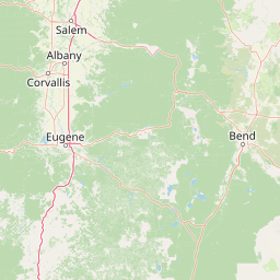

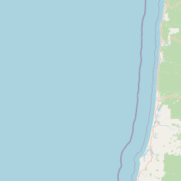

Leaflet | <a href="https://www.openstreetmap.org/copyright">© OpenStreetMap contributors</a>
Item
| Property | Value |
|---|---|
| id | 1440583 |
| downstream_mainstem_id | https://geoconnex.us/ref/mainstems/1432062 |
| encompassing_mainstem_basins | ['https://geoconnex.us/ref/mainstems/1432062', 'https://geoconnex.us/ref/mainstems/1430304', 'https://geoconnex.us/ref/mainstems/1426191', 'https://geoconnex.us/ref/mainstems/1423587'] |
| featuretype | ['https://www.opengis.net/def/schema/hy_features/hyf/HY_FlowPath', 'https://www.opengis.net/def/schema/hy_features/hyf/HY_WaterBody'] |
| fid | 30886 |
| head_2020huc12 | 170702030401 |
| head_nhdpv1_comid | 23681119 |
| head_nhdpv2_comid | https://geoconnex.us/nhdplusv2/comid/23681119 |
| head_nhdpv2huc12 | https://geoconnex.us/nhdplusv2/huc12/170702030401 |
| head_rf1id | 51809 |
| lengthkm | 59.1 |
| name_at_outlet | Long Creek |
| name_at_outlet_gnis_id | 1145398 |
| new_mainstemid | |
| outlet_2020huc12 | 170702030407 |
| outlet_drainagearea_sqkm | 528.0 |
| outlet_nhdpv1_comid | 23681037 |
| outlet_nhdpv2_comid | https://geoconnex.us/nhdplusv2/comid/23681037 |
| outlet_nhdpv2huc12 | https://geoconnex.us/nhdplusv2/huc12/170702030407 |
| outlet_rf1id | 51806 |
| superseded | False |
| uri | https://geoconnex.us/ref/mainstems/1440583 |