Muddy Creek
Map
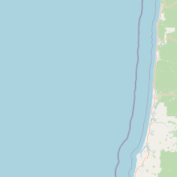
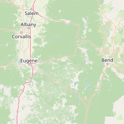


Leaflet | <a href="https://www.openstreetmap.org/copyright">© OpenStreetMap contributors</a>
Item
| Property | Value |
|---|---|
| id | 1446013 |
| downstream_mainstem_id | https://geoconnex.us/ref/mainstems/1441210 |
| encompassing_mainstem_basins | ['https://geoconnex.us/ref/mainstems/1441210', 'https://geoconnex.us/ref/mainstems/1426120', 'https://geoconnex.us/ref/mainstems/1423587'] |
| featuretype | ['https://www.opengis.net/def/schema/hy_features/hyf/HY_FlowPath', 'https://www.opengis.net/def/schema/hy_features/hyf/HY_WaterBody'] |
| fid | 31180 |
| head_2020huc12 | 170900030206 |
| head_nhdpv1_comid | 23765095 |
| head_nhdpv2_comid | https://geoconnex.us/nhdplusv2/comid/23765095 |
| head_nhdpv2huc12 | https://geoconnex.us/nhdplusv2/huc12/170900030206 |
| head_rf1id | 52619 |
| lengthkm | 53.8 |
| name_at_outlet | Muddy Creek |
| name_at_outlet_gnis_id | 1146614 |
| new_mainstemid | |
| outlet_2020huc12 | 170900030210 |
| outlet_drainagearea_sqkm | 320.3 |
| outlet_nhdpv1_comid | 23762959 |
| outlet_nhdpv2_comid | https://geoconnex.us/nhdplusv2/comid/23762959 |
| outlet_nhdpv2huc12 | https://geoconnex.us/nhdplusv2/huc12/170900030210 |
| outlet_rf1id | 52617 |
| superseded | False |
| uri | https://geoconnex.us/ref/mainstems/1446013 |