Charlotte Creek
Map


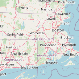

Leaflet | <a href="https://www.openstreetmap.org/copyright">© OpenStreetMap contributors</a>
Item
| Property | Value |
|---|---|
| id | 196821 |
| downstream_mainstem_id | https://geoconnex.us/ref/mainstems/194408 |
| encompassing_mainstem_basins | ['https://geoconnex.us/ref/mainstems/194408'] |
| featuretype | ['https://www.opengis.net/def/schema/hy_features/hyf/HY_FlowPath', 'https://www.opengis.net/def/schema/hy_features/hyf/HY_WaterBody'] |
| fid | 1399 |
| head_2020huc12 | 020501010403 |
| head_nhdpv1_comid | 8083911 |
| head_nhdpv2_comid | https://geoconnex.us/nhdplusv2/comid/8083911 |
| head_nhdpv2huc12 | https://geoconnex.us/nhdplusv2/huc12/020501010403 |
| head_rf1id | 3001 |
| lengthkm | 50.1 |
| name_at_outlet | Charlotte Creek |
| name_at_outlet_gnis_id | 946415 |
| new_mainstemid | |
| outlet_2020huc12 | 020501010406 |
| outlet_drainagearea_sqkm | 456.8 |
| outlet_nhdpv1_comid | 8086463 |
| outlet_nhdpv2_comid | https://geoconnex.us/nhdplusv2/comid/8086463 |
| outlet_nhdpv2huc12 | https://geoconnex.us/nhdplusv2/huc12/020501010406 |
| outlet_rf1id | 2995 |
| superseded | False |
| uri | https://geoconnex.us/ref/mainstems/196821 |