Mascoma River
Map
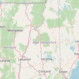
Leaflet | <a href="https://www.openstreetmap.org/copyright">© OpenStreetMap contributors</a>
Item
| Property | Value |
|---|---|
| id | 2278440 |
| downstream_mainstem_id | https://geoconnex.us/ref/mainstems/2277751 |
| encompassing_mainstem_basins | ['https://geoconnex.us/ref/mainstems/2277751'] |
| featuretype | ['https://www.opengis.net/def/schema/hy_features/hyf/HY_FlowPath', 'https://www.opengis.net/def/schema/hy_features/hyf/HY_WaterBody'] |
| fid | 677 |
| head_2020huc12 | 010801060101 |
| head_nhdpv1_comid | 9326874 |
| head_nhdpv2_comid | https://geoconnex.us/nhdplusv2/comid/9326874 |
| head_nhdpv2huc12 | https://geoconnex.us/nhdplusv2/huc12/010801060101 |
| head_rf1id | 1180 |
| lengthkm | 58.6 |
| name_at_outlet | Mascoma River |
| name_at_outlet_gnis_id | 868294 |
| new_mainstemid | |
| outlet_2020huc12 | 010801060106 |
| outlet_drainagearea_sqkm | 504.1 |
| outlet_nhdpv1_comid | 9327874 |
| outlet_nhdpv2_comid | https://geoconnex.us/nhdplusv2/comid/9327874 |
| outlet_nhdpv2huc12 | https://geoconnex.us/nhdplusv2/huc12/010801060106 |
| outlet_rf1id | 1178 |
| superseded | False |
| uri | https://geoconnex.us/ref/mainstems/2278440 |