Tahkenitch Creek
Map
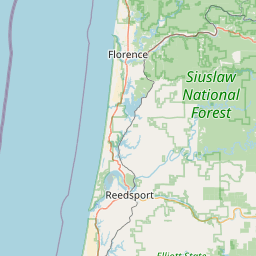


Leaflet | <a href="https://www.openstreetmap.org/copyright">© OpenStreetMap contributors</a>
Item
| Property | Value |
|---|---|
| id | 2322716 |
| downstream_mainstem_id | |
| encompassing_mainstem_basins | |
| featuretype | ['https://www.opengis.net/def/schema/hy_features/hyf/HY_FlowPath', 'https://www.opengis.net/def/schema/hy_features/hyf/HY_WaterBody'] |
| fid | 31463 |
| head_2020huc12 | 171002070104 |
| head_nhdpv1_comid | 23893327 |
| head_nhdpv2_comid | https://geoconnex.us/nhdplusv2/comid/23893327 |
| head_nhdpv2huc12 | https://geoconnex.us/nhdplusv2/huc12/171002070104 |
| head_rf1id | 55935 |
| lengthkm | 26.3 |
| name_at_outlet | Tahkenitch Creek |
| name_at_outlet_gnis_id | 1150838 |
| new_mainstemid | |
| outlet_2020huc12 | 171002070104 |
| outlet_drainagearea_sqkm | 92.6 |
| outlet_nhdpv1_comid | 23893303 |
| outlet_nhdpv2_comid | https://geoconnex.us/nhdplusv2/comid/23893303 |
| outlet_nhdpv2huc12 | https://geoconnex.us/nhdplusv2/huc12/171002070104 |
| outlet_rf1id | 53160 |
| superseded | False |
| uri | https://geoconnex.us/ref/mainstems/2322716 |