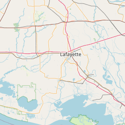
Bayou Tommy
Map
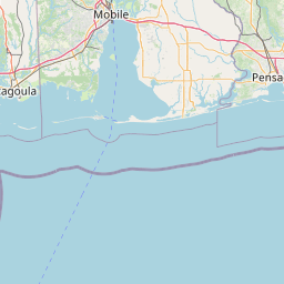
Leaflet | <a href="https://www.openstreetmap.org/copyright">© OpenStreetMap contributors</a>
Item
| Property | Value |
|---|---|
| id | 232762 |
| downstream_mainstem_id | https://geoconnex.us/ref/mainstems/227400 |
| encompassing_mainstem_basins | ['https://geoconnex.us/ref/mainstems/227400', 'https://geoconnex.us/ref/mainstems/225074'] |
| featuretype | ['https://www.opengis.net/def/schema/hy_features/hyf/HY_FlowPath', 'https://www.opengis.net/def/schema/hy_features/hyf/HY_WaterBody'] |
| fid | 13840 |
| head_2020huc12 | |
| head_nhdpv1_comid | 18715310 |
| head_nhdpv2_comid | https://geoconnex.us/nhdplusv2/comid/18715310 |
| head_nhdpv2huc12 | |
| head_rf1id | None |
| lengthkm | 23.1 |
| name_at_outlet | Bayou Tommy |
| name_at_outlet_gnis_id | 553533 |
| new_mainstemid | |
| outlet_2020huc12 | |
| outlet_drainagearea_sqkm | 221.9 |
| outlet_nhdpv1_comid | 18716836 |
| outlet_nhdpv2_comid | https://geoconnex.us/nhdplusv2/comid/18716836 |
| outlet_nhdpv2huc12 | |
| outlet_rf1id | None |
| superseded | False |
| uri | https://geoconnex.us/ref/mainstems/232762 |