Whatcom Creek
Map
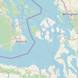
Leaflet | <a href="https://www.openstreetmap.org/copyright">© OpenStreetMap contributors</a>
Item
| Property | Value |
|---|---|
| id | 2333242 |
| downstream_mainstem_id | |
| encompassing_mainstem_basins | |
| featuretype | ['https://www.opengis.net/def/schema/hy_features/hyf/HY_FlowPath', 'https://www.opengis.net/def/schema/hy_features/hyf/HY_WaterBody'] |
| fid | 31679 |
| head_2020huc12 | 171100040602 |
| head_nhdpv1_comid | 24534812 |
| head_nhdpv2_comid | https://geoconnex.us/nhdplusv2/comid/24534812 |
| head_nhdpv2huc12 | https://geoconnex.us/nhdplusv2/huc12/171100040602 |
| head_rf1id | None |
| lengthkm | 23.7 |
| name_at_outlet | Whatcom Creek |
| name_at_outlet_gnis_id | 1509442 |
| new_mainstemid | |
| outlet_2020huc12 | 171100040700 |
| outlet_drainagearea_sqkm | 170.8 |
| outlet_nhdpv1_comid | 24534406 |
| outlet_nhdpv2_comid | https://geoconnex.us/nhdplusv2/comid/24534406 |
| outlet_nhdpv2huc12 | https://geoconnex.us/nhdplusv2/huc12/171100040700 |
| outlet_rf1id | None |
| superseded | False |
| uri | https://geoconnex.us/ref/mainstems/2333242 |