Saint Vrain Creek
Map
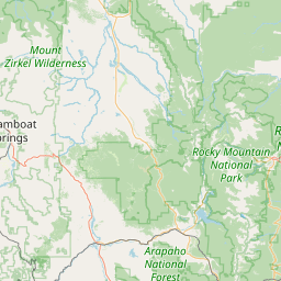
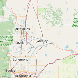
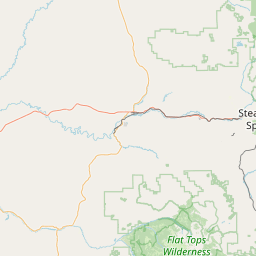
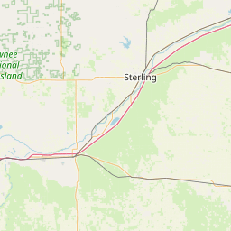
Leaflet | <a href="https://www.openstreetmap.org/copyright">© OpenStreetMap contributors</a>
Item
| Property | Value |
|---|---|
| id | 371269 |
| downstream_mainstem_id | https://geoconnex.us/ref/mainstems/313255 |
| encompassing_mainstem_basins | ['https://geoconnex.us/ref/mainstems/313255', 'https://geoconnex.us/ref/mainstems/312532', 'https://geoconnex.us/ref/mainstems/312091'] |
| featuretype | ['https://www.opengis.net/def/schema/hy_features/hyf/HY_FlowPath', 'https://www.opengis.net/def/schema/hy_features/hyf/HY_WaterBody'] |
| fid | 18009 |
| head_2020huc12 | 101900050202 |
| head_nhdpv1_comid | 2888594 |
| head_nhdpv2_comid | https://geoconnex.us/nhdplusv2/comid/2888594 |
| head_nhdpv2huc12 | https://geoconnex.us/nhdplusv2/huc12/101900050202 |
| head_rf1id | 22835 |
| lengthkm | 99.2 |
| name_at_outlet | Saint Vrain Creek |
| name_at_outlet_gnis_id | 205012 |
| new_mainstemid | |
| outlet_2020huc12 | 101900050709 |
| outlet_drainagearea_sqkm | 2536.3 |
| outlet_nhdpv1_comid | 2890930 |
| outlet_nhdpv2_comid | https://geoconnex.us/nhdplusv2/comid/2890930 |
| outlet_nhdpv2huc12 | https://geoconnex.us/nhdplusv2/huc12/101900050709 |
| outlet_rf1id | 62314 |
| superseded | False |
| uri | https://geoconnex.us/ref/mainstems/371269 |