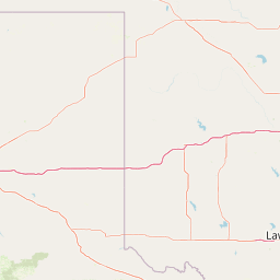
Sans Bois Creek
Map


Leaflet | <a href="https://www.openstreetmap.org/copyright">© OpenStreetMap contributors</a>
Item
| Property | Value |
|---|---|
| id | 376528 |
| downstream_mainstem_id | https://geoconnex.us/ref/mainstems/314446 |
| encompassing_mainstem_basins | ['https://geoconnex.us/ref/mainstems/314446', 'https://geoconnex.us/ref/mainstems/312091'] |
| featuretype | ['https://www.opengis.net/def/schema/hy_features/hyf/HY_FlowPath', 'https://www.opengis.net/def/schema/hy_features/hyf/HY_WaterBody'] |
| fid | 21575 |
| head_2020huc12 | 111101040201 |
| head_nhdpv1_comid | 1545531 |
| head_nhdpv2_comid | https://geoconnex.us/nhdplusv2/comid/1545531 |
| head_nhdpv2huc12 | https://geoconnex.us/nhdplusv2/huc12/111101040201 |
| head_rf1id | 35841 |
| lengthkm | 120.6 |
| name_at_outlet | Sans Bois Creek |
| name_at_outlet_gnis_id | 1102849 |
| new_mainstemid | |
| outlet_2020huc12 | 111101040216 |
| outlet_drainagearea_sqkm | 1068.2 |
| outlet_nhdpv1_comid | 1543945 |
| outlet_nhdpv2_comid | https://geoconnex.us/nhdplusv2/comid/1543945 |
| outlet_nhdpv2huc12 | https://geoconnex.us/nhdplusv2/huc12/111101040216 |
| outlet_rf1id | 37105 |
| superseded | False |
| uri | https://geoconnex.us/ref/mainstems/376528 |